Trail Walking Les Essarts-le-Roi - RELAIS D'ANJE 16 KM - Photo
 gemau77
gemau77

User

© OpenStreetMap contributors
Length
Length
16.6 km
Max alt
Max alt
194 m
Uphill gradient
Uphill gradient
128 m
Km-Effort
Km-Effort  
18.3 km
Min alt
Min alt
169 m
Downhill gradient
Downhill gradient
127 m
Boucle
Boucle
No
Creation date :
2019-03-18 15:01:35.58
Updated on :
2022-01-15 10:05:12.164

(0 Reviews)

Walking
Walking
3h57
Difficulty : Unknown

Scan this QR Code to open this trail in the SityTrail application

FREE GPS app for hiking

Logo SityTrail SityTrail

IGN / Geographical institutes

Download SityTrail from the App Store Download SityTrail from Google Play

Logo SityTrail SityTrail World

The world is yours!

Download SityTrail from the App Store Download SityTrail from Google Play Download SityTrail on Huawei AppGallery

About

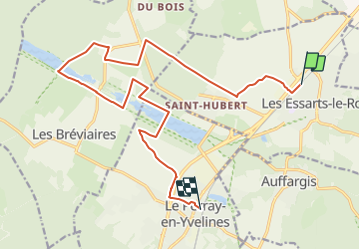
Trail Walking of 16.6 km to be discovered at Ile-de-France, Yvelines, Les Essarts-le-Roi. This trail is proposed by gemau77.

Elevation profile

Points of interest

Point of interest Le Perray-en-Yvelines - Bistrot - Photo
gemau77
LE PERRAY-EN-YVELINES 
Point of interest Les Bréviaires - Relais d'Anje - Photo
gemau77
LES BRÉVIAIRES 

Positioning

Country:
France
Region :
Ile-de-France
Department/Province :
Yvelines
Municipality :
Les Essarts-le-Roi
Location:
Unknown
Start:(UTM)
418386 ; 5397107 (31U) N.

Trails nearby

Trail Walking Auffargis - _Les 1000 facettes d''Auffargis - Photo
Walking
GUIDE+

Walking

Medium
(10)
Auffargis, Ile-de-France, Yvelines, France
10.2 km | 11.3 km-effort
2h 30min
Yes
Trail Walking Cernay-la-Ville - _Moulins des vaux de Cernay - Photo
Walking
GUIDE+

Walking

Easy
(9)
Cernay-la-Ville, Ile-de-France, Yvelines, France
6.3 km | 7.8 km-effort
2h 0min
Yes
Trail Walking Senlisse - _Sentier découverte des maréchaux - Photo
Walking
GUIDE+

Walking

Easy
(4)
Senlisse, Ile-de-France, Yvelines, France
4.3 km | 5.4 km-effort
1h 12min
Yes
Trail Walking Cernay-la-Ville - _Les Vaux de Cernay - Photo
Walking
GUIDE+

Walking

Medium
(3)
Cernay-la-Ville, Ile-de-France, Yvelines, France
8.4 km | 10.4 km-effort
2h 15min
Yes
Trail Walking Lévis-Saint-Nom - _L'Yvette - Photo
Walking
GUIDE+

Walking

Easy
(4)
Lévis-Saint-Nom, Ile-de-France, Yvelines, France
5.2 km | 7 km-effort
1h 29min
Yes
Trail Walking Le Perray-en-Yvelines - Les Vaux de Cernay - Photo
Walking
tracegps

Walking

Difficult
(4)
Le Perray-en-Yvelines, Ile-de-France, Yvelines, France
23 km | 26 km-effort
4h 45min
Yes
Trail Walking Le Perray-en-Yvelines - _La Rivière du Roi Soleil - Photo
Walking
GUIDE+

Walking

Medium
Le Perray-en-Yvelines, Ile-de-France, Yvelines, France
13.8 km | 15.3 km-effort
3h 20min
No
Trail Walking Lévis-Saint-Nom - _Girouard - Photo
Walking
GUIDE+

Walking

Medium
(1)
Lévis-Saint-Nom, Ile-de-France, Yvelines, France
8 km | 10 km-effort
2h 0min
Yes
Trail Walking Le Perray-en-Yvelines - étang d or gare du Perray  - Photo
Walking
topophil

Walking

Difficult
Le Perray-en-Yvelines, Ile-de-France, Yvelines, France
14.7 km | 16.2 km-effort
3h 41min
No


Close
My subscriptions